| Issue |
BIO Web Conf.
Volume 11, 2018
IV(VI)th All-Russia Scientific-Practical Conference “Prospects of Development and Challenges of Modern Botany”
|
|
|---|---|---|
| Article Number | 00008 | |
| Number of page(s) | 5 | |
| DOI | https://doi.org/10.1051/bioconf/20181100008 | |
| Published online | 21 August 2018 | |
Forest vegetation assessment using geoinformation tools: a case of the Burla pine forest, Novosibirsk Region, Russia
1
Central Siberian Botanical Garden, Siberian Branch of the Russian Academy of Sciences, Novosibirsk, 630090, Russian Federation
2
Siberian State University of Geosystems and Technologies, Novosibirsk, 630108, Russian Federation
* Corresponding author: This email address is being protected from spambots. You need JavaScript enabled to view it.
Abstract
The paper presents the vegetation thematic classification of the Burla banded pine forest carried on using "Canopus-V" remote sensing data and the supervised classification technique by a spectral angle mapper. Areas of selected elements have been assessed: 1. Pine forests, 2. Birch forests; 3. Meadows; 4. Anthropogenic objects (roads, etc.); 5. Agricultural lands; 6. Water objects. Sites of anthropogenic disturbed forests are identified according to remote sensing data. The results show that the data obtained in the classification by a spectral angle can be used to compile geobotanical maps, but due to low spectral resolution of Canopus-V satellite data, it is not always possible to classify individual objects validlys.
© The Authors, published by EDP Sciences, 2018
 This is an Open Access article distributed under the terms of the Creative Commons Attribution License (http://creativecommons.org/licenses/by/4.0), which permits unrestricted use, distribution, and reproduction in any medium, provided the original work is properly cited.
1 Introduction
Techniques of the Earth multispectral remote sensing are widely used to interpretate forest areas based on differences between their spectral properties recent decades. The data obtained allow mapping large areas, at the same time make it possible to draw preliminary conclusions about the nature of anthropogenic impact [1, 2, 3].
Pine forests have been attracting scholars' attention since the mid last century up to the present due to their large economic value [4, 5, 6, 7, 8, 9; 10, 11]. It was ascertained that intensive economic activity led to anthropogenic transformation of natural ecosystems. The share of pine forests was 92% in 1934, than it decreased to 83% by mass cuttings in 1963 [6, 12]. The banded forests were regarded as the raw material base permitting to receive high-quality wood, and their rational management was not taken into account. When the protective role of the banded forests was established and forest farms began actively restored, the area covered by the forest decreased from 288,000 to 85,000 hectares (as of 2015). However, planned logging operations are necessary, but should take into account biological features and environmental conditions of pine ecosystems [13, 14].
At the backdrop of the pine felling problems the issue of fires is acute as well. Many authors note not only an exceptionally high natural fire hazard of banded forests, but temperature background rising, which lead to forest fires, their maximum was marked in 1990-1999. It has been established that fire careless handling is the main factor of fires [15, 16, 17, 18, 19].
Thus, anthropogenic impact on pine forests results natural community transformation, therefore complex monitoring of banded forests is necessary nowadays helping to solve a number of problems. Using the algorithms for decoding remote sensing data serves to identify quickly the damage foci and support operatively the security measure complex elaboration.
The main drawback of the most algorithms used is that each pixel in an image is compared with signatures of a test site (polygon) identified in the field and marked as a class. The supervised classification technique by a spectral angle mapper (SAM) allows comparing each pixel of an image with every finite element for each class and assigns a weighted value between 0 (low similarity) and 1 (high similarity). As a result, it is possible to obtain a classified image promptly and identify anthropogenic impact foci. The work objective is to assess SAM algorithm operation and determine the scale maximum possible for geobotanical mapping based on remote sensing Canopus-B data and field studies.
2 Materials and Methods
2.1 Study object
Pine banded forests are unique natural objects not only in scales of Siberia, but throughout Russia as well. They have come into being on alluvial sands along the ancient runoff valleys in steppe and forest-steppe zones. Pine forests bands (4-15 km width and 400 km length) stretch from northeast to southwest forming special climatic and soil conditions [20, 21].
Banded forests are situated in sharply continental climate regions with annual precipitation of 320 mm, significant temperature fluctuations up to 88 °C annual and 22 °C daily. These territories are characterized by hot dry winds, where pine forests act as a constraint [22]. Ridge-hilly relief causes the vegetation cover diversity in these forests. Due to such natural condition combination banded forests are unique, and preserve habitats of rare plant and animal species [23].
To achieve the objective, test sites were selected in the Burla forest band. It is located at Altai Territory mainly and its part enters southern Novosibirsk region. The band begins 35 km north of Kamen'-on-Ob city at the Ob reservoir shore and stretches from northeast (N54°14'05.78 "E81°39'59.60") to southwest (N53°46'12.10 "E80° 07'37.40") for 114 km with 8-10 km width. The bottom of the forested valley is 150-180 m altitude above sea level. The Priobskoe Plateau surrounding parts rise above it by 60-100 m. The surface sediments are sands underlying by clay shallow layers and lenses, which are waterproof deposits [24]].
2.2 Earth Remote Sensing Space System
Russian satellite Canopus-V remote sensing data have been used (surveying June 27, 2017). This space complex is designed to monitor man-made and natural emergencies, to detect forest fire foci, and can be used to map vegetation at a scale of 1 : 50,000 as well. It is known that for mapping at 1 : 25,000 scale with a minimum allowable index of map content, space images with a linear resolution not less than 2.5 m should be used. The obtained data have the following resolutions: panchromatic – 2.1 m gt; multispectral – 10.5 m. Spectral ranges are panchromatic (P) – 0.52-0.85 μm; blue (B) – 0.46-0.51 μm; green (G) – 0.54-0.6 μm; red (R) – 0.63-0.66 μm; near infrared (Nir) – 0.75-0.86 μm [25]. Applying a Pan-sharpening function, proper data for the vegetation visual interperting, and relevant materials for mapping at 1 : 25,000 scale can be got.
2.3 Geoinformatiom methods
The applied image processing technology allows identifying images in accordance with their spectral signatures in a semi-automatic mode (supervised classification). There are several types of classification algorithms, but the general purpose is to compile the vegetation thematic map of. At the first stage, a composite raster has been created by five bands: P, R, G, B, Nir. An image obtained by four channels (R, G, B, Nir) is used for classifying and creating spectrograms. At the second stage, a shapefile of the regions of interest (ROI) and signatures has been generated. Areas have been singled out by polygon capture of pixels. The test sites determined by routing geobotanical study have been chosen: 1. Pine forests, 2. Birch forests; 3. Meadows; 4. Anthropogenic objects (roads, etc.); 5. Agricultural lands; 6. Water objects. The supervised classification algorithm by SAM has been used for classifying. Preliminary processing of Canopus-V remote sensing data, classification and final maps arranging have been carried on with free cross-platform geoinformation system QGIS [26] applying a semi-automatic classification module Plugin [27, 28], projection code is EPSG: 32644.
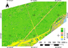 |
Fig. 1. A map fragment of the Burla forest. |
3 Results
As a result of applying the supervised classification technique by SAM based at test sites of five classes set at an assigning stage, the areas of different vegetation units identified (Fig. 1). When classifying vegetation, the result accuracy depends directly on the remote sensing data resolution. In our case, the resolution of Canopus-V remote sensing data is 10×10 m, so if the object (roads, local felling, etc.) size in an image cell is less than the image resolution, the pixel reflection coefficient is a linear combination of reflection coefficients of all surface types entering this pixel, which leads to some misrepresentation of the classification results. Due to the similarity of spectral signatures of disturbed territories with a size less than remote sensing data resolution with the signatures of the open soil (road), the classifier could not uniquely distinguish them, therefore the swamped lake coastal areas fell into the group of anthropogenic objects (4). The same happened with agricultural lands (5): some of anthropogenic objects (4) were classified as croplands (5). Therefore, it was decided to allocate all the disturbed territories to a separate class. This does not play a significant role in the area estimation of vegetation types, as the most of the studied objects are slightly impacted by anthropogenic effect. When assessing the accuracy of SAM technique applied, high values have been marked and the same common accuracy is shown. In general, the use of classification by SAM allows determining the areas of the identified vegetation types the most accurate.
4 Discussion
This work on the vegetation classification makes it possible to assess the suitability of the remote sensing data analysis for monitoring the Burla banded pine forest. Using remote sensing data from the Russian satellite Canopus-V and semi-automatic algorithms permits to obtain initial materials for interpretring vegetation and further mapping at 1: 25,000 scale. The classification finalization enables to identify anthropogenic objects (cut and burned sites, roads, etc.). As noted above, anthropogenic objects of small sizes have some errors in defining their class and areas, but still with considerable accuracy it is possible to reveal disturbed territories. The natural vegetation (a vegetative component) analysis of the studied region is of major importance. Despite the revealed potential problems of the classification process, the maps obtained can be an additional predictor for geoinformation modeling, and serve the purposes of analyzing anthropogenic and natural changes in forest ecosystems.
The project supported by RFBR (Grant No 16-05-00908 A) and research was carried on in frameworks of base projects of the Central Siberian Botanical Garden, the Siberian Branch of the Russian Academy of Sciences (Project no. VI.52.1).
References
- Zh. Li, D. Limin, G. Shao, X. Dong, W. Hui, B. Jianwei, Science in China. E. 49, 167-176 (2006) [CrossRef] [Google Scholar]
- L. Altun, E.Z. Baskent, A. Gunlu, A.I. Kadiogullari, Environ Monit Assess. 137:149-161 (2008) [CrossRef] [PubMed] [Google Scholar]
- S. Arekhi, A.A. Jafarzadeh, Arab. J Geosci. 7:1073-1085 (2014) DOI 10.1007/s12517-012-0785-1 [CrossRef] [Google Scholar]
- P.L. Gorchakovsky, Bot J. 34, 525-538 (1949). (In Russ.) [Google Scholar]
- G.G. Pavlova, Vegetation of steppe and forest-steppe zones in West Siberia 6, 131-162 (1963) (In Russ.) [Google Scholar]
- I.V. Taran, West Siberian pine forests (Nauka, Novosibirsk, 1973) (In Russ.) [Google Scholar]
- I.A. Khrustalyova, Bulletin of Altai State Agricultural University 8, 32-35 (2008) (In Russ.) [Google Scholar]
- I.A. Khrustalyova, Plant Life of Asian Russia 2, 54-65 (2009). (In Russ.) [Google Scholar]
- T.A. Teryokhina, T.M. Kopytina, P.A. Kosachev, N.V. Elesova, N.V. Ovharova, Proc. South. Siber. Bot. Garden 12, 54-65 (2008) (In Russ.) [Google Scholar]
- N.N. Lashchinsky, A.Yu. Korolyuk, N.V. Lashchinskaya, Plant Life of Asian Russia 2, 63-84 (2017) (In Russ.) [Google Scholar]
- N.N. Lashchinsky, A.Yu. Korolyuk, M.P. Tishchenko, N.V. Lashchinskaya. Asian Russia Vegetative Kingdom 1, 57-81 (2018). (In Russ.) [Google Scholar]
- A.E. Osipenko, E.M. Ananiev, A.A. Gof, V.V. Savin, D.A. Shubin, News of the Orenburg State Agrarian university 6, 98-101 (2017). (In Russ.) [Google Scholar]
- A.A. Maslenko, M.I. Semenov, V.A. Elizarov, Bulletin of Altai State Agricultural University 12, 54-57 (2012). (In Russ.) [Google Scholar]
- E.G. Paramonov, Bulletin of Altai State Agricultural University 8, 55-59 (2014). (In Russ.) [Google Scholar]
- L.P. Barannik, V.I. Zablotsky, Bulletin of Altai State Agricultural University 3, 61-64 (1999). (In Russ.) [Google Scholar]
- E.G. Paramonov, Ya.N. Ishutin, Large forest fires in Altai Region (Del’ta, Barnaul, 1999). (In Russ.) [Google Scholar]
- E.Yu. Neverova, A.A. Malinovskikh, Bulletin of Altai State Agricultural University 12, 58–61 (2012) (In Russ.) [Google Scholar]
- I.M. Frolenkov, O.M. Frolenkov, World Science, Culture, Education 1, 394-397 (2014) (In Russ.) [Google Scholar]
- E.G. Paramonov, I.D. Rybkina, Sustainable Forestry 3, 33-39 (2017). (In Russ.) [Google Scholar]
- L.N. Gribanov, Banded pine forests in Altai Region and Kazakhstan (Sel’khozgiz, Moscow, 1954). (In Russ.) [Google Scholar]
- G.V. Zanin, Natural zoning of the Altai territory 1, 62-98 (1958). (In Russ.) [Google Scholar]
- A.P. Slyadnev, Ya.P. Fel’dman, Natural zoning of the Altai territory 1, 9-61 (1958) (In Russ.) [Google Scholar]
- The red book of the Altai Region: rare and endangered plant species. Vol. 1 (Altai Univ. Publ., Barnaul, 2006). (In Russ.) [Google Scholar]
- I.P. Gerasimov, Materials to the geomorphology of the Kulunda steppe 10, 9-33 (1935) (In Russ.) [Google Scholar]
- A.V. Vladimirov, R.S. Salikhov, N.A. Senik, S.A. Zolotoi, Problems Electromechanics 105, 49-57 (2008) (In Russ.) [Google Scholar]
- QGIS Development Team. QGIS geographic information system. Open Source Geospatial Foundation (OSGeo). URL: https://qgis.org/ru/site/index.html (accessed 30.05.2018). [Google Scholar]
- L. Congedo, M. Munafò, S. Macchi, Investigating the relationship between land cover and vulnerability to climate change in Dar es Salaam (Sapienza Univ., Rome, 2013). [Google Scholar]
- L. Congedo, Semi-automatic classification Plugin. Documentation. Release 6.1.0.1, 2018, URL: https://media.readthedocs.org/pdf/semiautomaticclassificationmanual/latest/semiautomaticclassificationmanual.pdf (accessed 30.05.2018) [Google Scholar]
All Figures
|
Fig. 1. A map fragment of the Burla forest. |
| In the text | |
Current usage metrics show cumulative count of Article Views (full-text article views including HTML views, PDF and ePub downloads, according to the available data) and Abstracts Views on Vision4Press platform.
Data correspond to usage on the plateform after 2015. The current usage metrics is available 48-96 hours after online publication and is updated daily on week days.
Initial download of the metrics may take a while.