| Issue |
BIO Web Conf.
Volume 16, 2019
“Results and Prospects of Geobotanical Research in Siberia”, dedicated to the 75th anniversary of the laboratory of ecology and geobotany of CSBG SB RAS
|
|
|---|---|---|
| Article Number | 00028 | |
| Number of page(s) | 6 | |
| DOI | https://doi.org/10.1051/bioconf/20191600028 | |
| Published online | 15 October 2019 | |
Space structure and diversity of island vegetation on Torey lakes in drought period in Daursky reserve
Daursky State Nature Biosphere Reserve, Nizhniy Tsasuchey,
76 Komsomolskaya Str.,
Zabaikalsky krai, Russia
* Corresponding author: This email address is being protected from spambots. You need JavaScript enabled to view it.
Abstract
The Torey lakes of Daursky reserve belong to wetlands of international importance and are located in the south of Zabaikalsky krai. In 2009, in the drought period, we studied the space structure and diversity of the vegetation on five islands in the Torey lakes. The results of ecological-phytocenotic classification are presented. 52 associations related to 15 formations and 4 types of island vegetation on the Torey lakes are identified.
© The Authors, published by EDP Sciences, 2019
 This is an Open Access article distributed under the terms of the Creative Commons Attribution License 4.0, which permits unrestricted use, distribution, and reproduction in any medium, provided the original work is properly cited.
1 Introduction
The Daursky nature reserve with the area of 49,764 ha, and the buffer zone of 173,201 ha is located in the south of Transbaikal territory at the border with Mongolia. The reserve includes the Torey lakes inscribed in the list of wetlands of international importance under Ramsar convention. The Torey lakes consist of soda lakes Barun-Torey and Zun-Torey. The Torey lakes are at the intersection of two powerful bird flyways − the Eastasian- Australasian and Eastasian-Indian ones. Barun-Torey Lake feeds the steppe Ulda and Imalka rivers. Zun-Torey Lake feeds atmospheric precipitation and the groundwater to the surface. In the aquatorium of Torey lakes there are eleven islands of different area (Fig. 1). The islands serve as a nesting site for colonial semiaquatic birds including rare ones, such as Relict gull (Larus relictus). The islands of Torey section are one of the world’s four nesting sites of Relict gull.
The reserve is situated in the zone of extremely continental climate. The peculiar feature of the climate is great amplitude of fluctuations in 24-hour and year temperatures, and uneven distribution of seasonal and many-year precipitation. 24-hour fluctuations of temperature reach 15−20°С, and year ones − 80°С. During dry years 150 mm precipitation fall, in wet years − up to 350 mm. Cyclic changes in humidity with alternation of drought and wet periods about 30 years in duration are characteristic of Dauria [1]. The Torey lakes have a changeable hydrological pattern. On the map charts based on the deciphering of space shots changes in the area of the water surface of the Torey lakes are observed (Fig.2). In the wet period in 2000 the area of the Torey lakes water surface was 852 km2, in 2005 − 750 km2, in 2007 −650 km2, in 2008 − 550 km2, in 2009 г. − 285 km2. The year 2009 was the most
droughty. In May 2009 Lake Barun-Torey dried up. Lake Zun-Torey got considerably low and the island Aral of the Zun-Torey joined the shore.
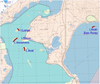 |
Fig. 1 Location of studied islands on Torey lakes |
 |
Fig. 2 Monitoring of the area of Torey lakes water surface in 2000-2009 rivers Uldza, Imalka that fill the Torey lakes dried up. A lot of small steppe lakes in the Torey hollow ran dry. |
2 Materials and methods
In 2009 we studied five islands: Alexandria (area − 11 km2), Aral (8.5 km2), Bolshoy (8.7 km2), Kamenny (0.6 km2) and Aral of the Zun-Torey (5.1 km2). On each island we laid a geobotanical profile. Geobotanical descriptions of the vegetation were conducted according to the standard methodology [2]. This paper is based on the material from 78 geobotanical descriptions of the islands vegetation. Classification of the island vegetation on the Torey lakes was done on the ecologo-phytocenotic principles laid out by E.M. Lavrenko [3]. To associations we ascribe communities with a unified composition of edificators and co- edificators, homogeneous synusial structure. Formations are identified by the basic edificator and are joined into groups.
3 Results and discussion
The purpose of the study is describing the space structure and diversity of the vegetation on five islands of the Torey lakes in the droughty period.
We considered a typical example of the distribution of island vegetation belts on the geobotanical profile of the Bolshoy island (Fig. 3). The profile has a total length of 1 km 140 m, is oriented from the south-east to north-west and laid across the top of the island (with a height of 609 m above sea level).The spatial distribution of vegetation is shown in Fig. 3 at the level of ecological-phytocenotic classification formations, the description is made at the level of associations. The main influence on the distribution of vegetation has a position of associations in the relief. The relief is generally flat-flat, from the top to the coastal shaft, gently sloping (angle of inclination up to 3 degrees) slopes descend.
On the shores and smooth slopes of the island Bolshoy we distinguish three meadow formations − Argusia, Saltmarsh-grass and Seepweed ones. The Seepweed formation (1, 10) comprises seepweed (Suaeda corniculata) and Suaeda corniculata − Knorringia sibirica associations. The coastal areas of the island, recently freed from the water, are captured by the pioneer halophytic associations from Suaeda corniculata. Puccinellia formation (2) is represented by the association of the same name, in which the main dominants are Puccinellia tenuiflora and P. macranthera. The Argusia formation (3, 9) includes association Argusia rosmarinifolia − Puccinellia tenuiflora. The upper convex part of the island is occupied by steppe vegetation of Leymus and Stipa formations. The Leymus formation (5, 7) includes association Leymus chinensis − Allium polyrhizum; the Stipa formation (6, 8) − association Stipa krylovii − Caragana stenophylla. The reed formation (4), described by us in the middle part of the southeastern slope, consists of hydrophyte monodominant species Phragmites australis thickets. Reed thickets in the dry period occupy small areas.
The islands of the Torey Lakes are natural refugiums for rare species and associations. Five rare species have been found on the islands: Asparagus brachyphyllus, a species listed in the Red Book of the Russian Federation [4] and Ephedra dahurica, Limonium aureum, Nitraria sibirica, Astragalus miniatus, species included in the Red Book of the Transbaikal territory [5]. Of the rare and endemic associations, the following were described: Oxytropis prostrata − Suaeda corniculata, Oxytropis prostrata − Melilotus suaveolens − Argusia rosmarinifolia with the participation of the endemic species Oxytropis prostrata; and Argusia rosmarinifolia − Convolvulus ammanii, Argusia rosmarinifolia − Puccinellia macranthera − Knorringia sibirica, Artemisia anethifolia − Nitraria sibirica, Argusia rosmarinifolia − Puccinellia macranthera − Puccinellia tenuiflora, with Argusia rosmarinifolia xerophilous tertiary desert-steppe Central Asian relict.
A change of vegetation from halophytic to steppe communities is characteristic of almost all studied islands. An exception is island Kamenny, which has small area − 0.6 km2. In the vegetation of the island, of pioneer seepweed, seepweed-orach, orach associations with participation of annual and biennial halophytic species Atriplex fera and Suaeda corniculata are described. Steppe vegetation is not developed due to the small area of the island. Hydrophytic vegetation is represented by the Reed formation. Thickets of reeds are noted for the Aral, Alexandria and Bolshoy Islands. In the dry season, reed areas degrade and shrink. Below is the ecologo-phytocenotic classification of the island vegetation of the Torey lakes (Table)
Thus, the analysis of the spatial structure of vegetation showed that the change of plant associations and formations is closely related to the position in the relief: the areas with similar relief have similar vegetation that varies from halophytic to steppe associations. Such a structure of vegetation is characteristic of the large islands of Alexandria, Bolshoi, Aral and Aral-Zun-Torey. As a rule, pioneer and halophytic vegetation grows along the coast and in the coastal zone of the islands. On the gentle slopes of the islands, it is replaced by halophytic saltmarsh-grass meadows, with spots of hydrophytic reed vegetation. On convex summit relief forms, halophytic vegetation is replaced by steppe vegetation. During the dry period, an increase in the area of pioneer halophytic vegetation and a decrease in hydrophytic vegetation were observed on the islands. The diversity of island vegetation of the Torey Lakes is represented by 52 associations belonging to 16 formations and 4 types of vegetation. The islands of the Torey Lakes are natural refugiums for rare species and endemic associations.
 |
Fig. 3 Vegetation of Bolshoy island. Formations: 1, 10. Seepweed; 2. Saltmarsh-grass; 3, 9. Argusia; 4. Reed; 5, 7. Leymus; 6, 8 Stipa |
Ecologo-phytocenotic classification of the island vegetation of the Torey lakes
References
- V. Kirilyuk, T. Tkachuk, O. Kirilyuk, Problems of adaptation to climate change in Dauria river basins: ecological and hydroeconomic aspects, 5 (2012) [Google Scholar]
- Field geobotany, 3 (L., 1964) [Google Scholar]
- E.M. Lavrentyev, Vegetation of USSR, 2 (M, 1940) [Google Scholar]
- The Red Book of the Russian Federation (plants and fungi) (M, КМК, 2008) [Google Scholar]
- Red Book of the Trans-Baikal Territory. Plants (Novosibirsk, House of peace, 2017) [Google Scholar]
All Tables
All Figures
|
Fig. 1 Location of studied islands on Torey lakes |
| In the text | |
|
Fig. 2 Monitoring of the area of Torey lakes water surface in 2000-2009 rivers Uldza, Imalka that fill the Torey lakes dried up. A lot of small steppe lakes in the Torey hollow ran dry. |
| In the text | |
|
Fig. 3 Vegetation of Bolshoy island. Formations: 1, 10. Seepweed; 2. Saltmarsh-grass; 3, 9. Argusia; 4. Reed; 5, 7. Leymus; 6, 8 Stipa |
| In the text | |
Current usage metrics show cumulative count of Article Views (full-text article views including HTML views, PDF and ePub downloads, according to the available data) and Abstracts Views on Vision4Press platform.
Data correspond to usage on the plateform after 2015. The current usage metrics is available 48-96 hours after online publication and is updated daily on week days.
Initial download of the metrics may take a while.